Major improvement works to take place on the Argyle line.
From 13 March until 8 May 2022, major improvement works on the track, tunnels and overhead line equipment between Rutherglen and the Exhibition Centre are taking place, with the line closed and no services running during this time.
Many services, which would normally operate via Glasgow Central Low Level, are being diverted into Glasgow Central High Level or Glasgow Queen Street Low Level. Revised services are operating on all routes during the closure, and journey times may be extended on some services to allow for trains taking a diverted route.
Click here to download map of affected routes
Travel advice
We've provided some information and travel advice below for stations and line of routes which are affected by the tunnel closure to help you plan your journey.
If travelling to Glasgow city centre from either side of the route closure, we recommend you travel via rail, either using Glasgow Central High Level or Glasgow Queen Street Low Level. Please note, some journeys will take longer and trains may be busier.
If you normally travel to the city centre from one of the closed stations, local bus services may be a quicker option for you. You may also wish to consider using a ZoneCard, which can be used on local bus services, subway and train services/rail replacement. To buy a ZoneCard for the first time, go to any staffed ScotRail station with a passport-sized photo of yourself and select the zones you want to travel in. Click here for more information about ZoneCards.
Those with accessibility needs, who require assistance, can use rail replacement to complete their journeys.
Be prepared and plan your journey in advance.
Closed stations
The stations listed below are closed for the duration of the works. Please see travel advice and alternate journey information below:
There are no train services running to or from this station throughout the period of the closure.
Rail replacement is not a viable option for travelling to events at the SEC/Hydro.
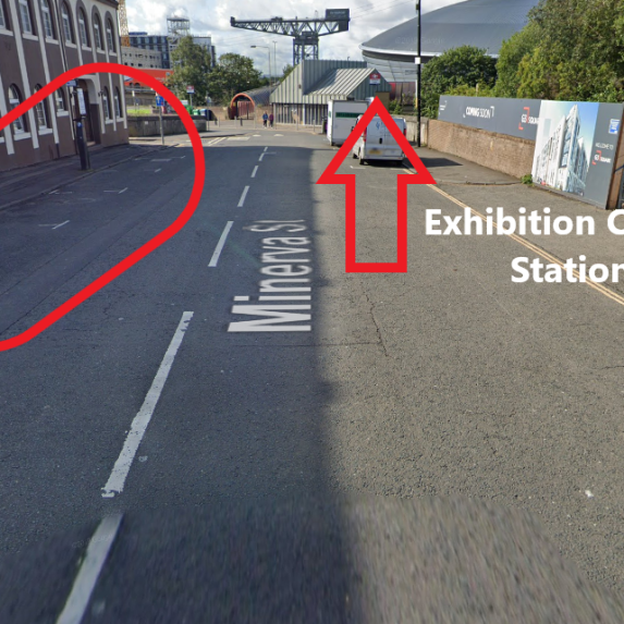
A rail replacement service* will operate every half hour Monday to Sunday, in each direction. These services will pick up/drop off from Minerva Street.
Rail replacement should be used if travelling to Glasgow Central, Bridgeton, Dalmarnock or Rutherglen.*
If travelling towards Helensburgh, Balloch, Dalmuir and Milngavie, take rail replacement to Partick and then connect with rail services.
If travelling towards Whifflet, Motherwell, Lanark and Larkhall, take rail replacement to Glasgow Central and then connect with rail services at Glasgow Central (High Level).
You must have a valid rail ticket to travel on the rail replacement services - these cannot be purchased onboard rail replacement. Tickets can be purchased before travelling online or via the ScotRail App , or at station ticket offices or ticket vending machines.
*The rail replacement service will not stop at Argyle Street or Anderston.
Image of Exhibition Centre rail replacement pick up/drop off point.
First Bus, service no.2, for travel between the Exhibition Centre and Glasgow Central. For more information, see First Bus website.
Stagecoach, service X19, for travel between the Exhibition Centre and Glasgow Central. For more information, see Stagecoach website.
McGill’s, services 23 and 26, for travel between the Exhibition Centre and Glasgow Central. For more information, see McGill's website.
Please note that these services may require a walk to the bus stop.
Buy your ticket directly from the local bus operator. Rail tickets cannot be used on local bus services.
Cycling may be an option between the Exhibition Centre and the City Centre or the other closed stations. More details can be found by visiting Sustrans website.
There are options to hire a bike via NextBike.
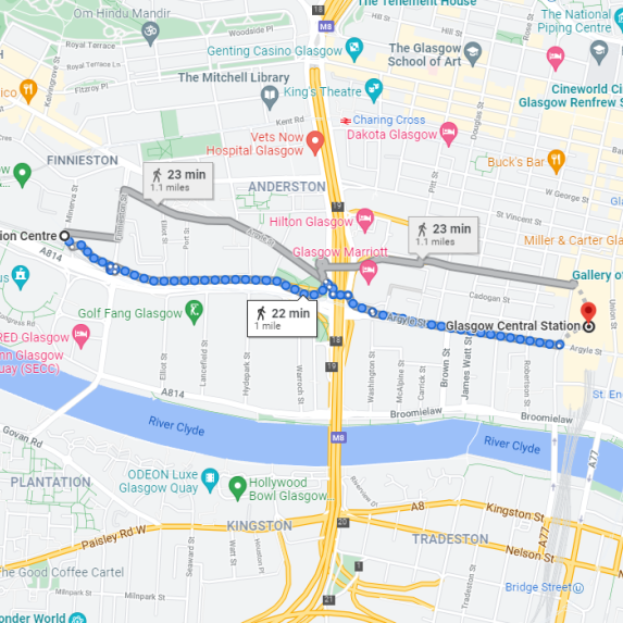
On average it takes 25 minutes to walk between the Exhibition Centre and Glasgow Central. See below map for detailed route:
Click here for details of the facilities available at the above mentioned stations.
There are no train services running to or from this station throughout the period of the closure.
There is no rail replacement running from this station throughout the period of the closure. However, the rail replacement service will operate from Glasgow Central (circa 15 minute walk).
First Bus, services no.18, 21, 64, 65, 263 and 267, for travel between Anderston (will require a walk in to Glasgow City Centre) and Bridgeton, Dalmarnock or Rutherglen. For more information, see First Bus website.
Please note that there are regular bus services that run from the bus stop outside the Marriot Hotel towards the St Enoch Centre where you can interchange with the above bus services.
Buy your ticket directly from the local bus operator. Rail tickets cannot be used on local bus services.
Cycling may be an option between Anderston and the closed stations. More details can be found on Sustrans website.
There are options to hire a bike via NextBike.
On average it takes around 15 minutes to walk from Anderston station to Glasgow Central station, where you can connect with rail services (from the High Level) towards Whifflet, Motherwell, Lanark and Larkhall. See map for detailed route:
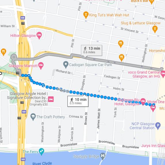
On average it takes around 20 minutes to walk from Anderston station to Argyle Street station. See map for detailed route:
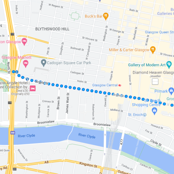
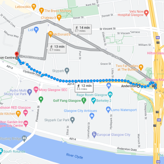
On average it takes around 15 minutes to walk from Anderston station to Exhibition Centre station. See map for detailed route:
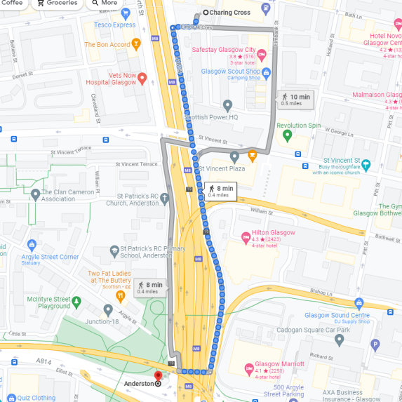
On average it takes around 10 minutes to walk from Anderston station to Charing Cross station, where you can connect with rail services towards Helensburgh, Balloch, Dalmuir and Milngavie. See map for detailed route:
Click here for details of the facilities available at the above mentioned stations.
There are no train services running from this station throughout the period of the closure.
There are, however, services running from Glasgow Central High Level towards Whifflet, Motherwell, Lanark and Larkhall.
A rail replacement service will operate every half hour Monday to Sunday, in each direction. These services will pick up/drop off from Gordon Street.
You must have a valid rail ticket to travel on the rail replacement services - these cannot be purchased onboard rail replacement. Tickets can be purchased before travelling online or via the ScotRail App , or at station ticket offices or ticket vending machines.
First Bus, service no.2, for travel between Glasgow Central and the Exhibition Centre. This service leaves from the bus stop on Hope Street. For more information, see First Bus website.
Stagecoach, service X19, for travel between Glasgow Central and the Exhibition Centre. This service leaves from the bus stop on Union Street. For more information, see Stagecoach website.
First Bus, services no.18, 21, 64, 65, 263 and 267, for travel between Glasgow Central and Bridgeton, Dalmarnock or Rutherglen. These services leave from the bus stop on Union Street. For more information, see First Bus website.
Buy your ticket directly from the local bus operator. Rail tickets cannot be used on local bus services.
Cycling may be an option between Glasgow Central and the closed stations. More details can be found on Sustrans website.
There are options to hire a bike via NextBike.
On average it takes between 5 and 10 minutes to walk from Glasgow Central station to Glasgow Queen Street station, where you can connect with rail services (from the Low Level) towards Helensburgh, Balloch, Dalmuir and Milngavie. See map for detailed route:
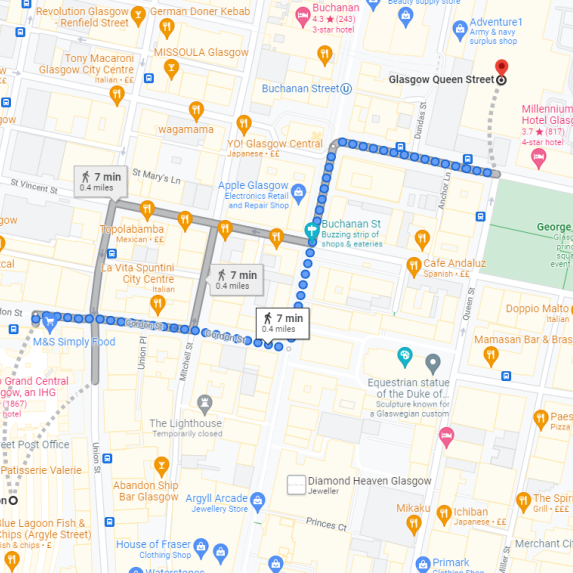
On average it takes around 25 minutes to walk between Glasgow Central station and the Exhibition Centre station. See map for detailed route:

On average it takes around 15 minutes to walk from Glasgow Central station to Anderston station. See map for detailed route:

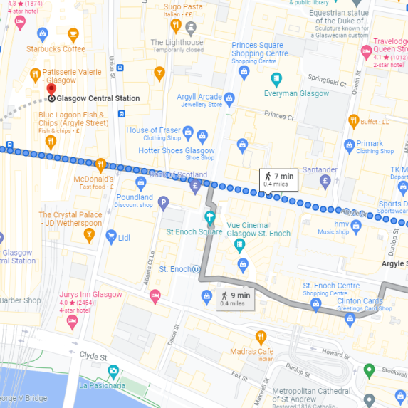
On average it takes around 10 minutes to walk from Glasgow Central station to Argyle Street station. See map for detailed route:
Click here for details of the facilities available at the above mentioned stations.
There are no train services running from this station throughout the period of the closure.
There is no rail replacement running from this station throughout the period of the closure. However, the rail replacement service will operate from Glasgow Central (circa 10 minute walk).
First Bus, services no.18, 21, 64, 65, 263 and 267, for travel between Argyle Street and Bridgeton, Dalmarnock or Rutherglen. These services leave from the bus stops on Glassford Street/Stockwell Street. For more information, see First Bus website.
First Bus, service no.2, for travel between Argyle Street and the Exhibition Centre (may require a walk to bus stop/s). This service leaves from the bus stop behind the St Enoch Centre on Stockwell Place. For more information, see First Bus website.
Buy your ticket directly from the local bus operator. Rail tickets cannot be used on local bus services.
Cycling may be an option between Argyle Street and the closed stations. More details can be found on Sustrans website.
There are options to hire a bike via NextBike.
On average it takes around 10 minutes to walk from Argyle Street station to Glasgow Central station, where you can connect with rail services (from the High Level) towards Whifflet, Motherwell, Lanark and Larkhall. See map for detailed route:

On average it takes around 20 minutes to walk from Argyle Street station to Anderston station. See map for detailed route:

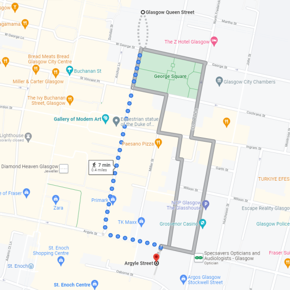
On average it takes around 10 minutes to walk from Argyle Street station to Queen Street station, where you can connect with rail services towards Helensburgh, Balloch, Dalmuir and Milngavie. See map for detailed route:
Click here for details of the facilities available at the above mentioned stations.
There are no train services running to or from this station throughout the period of the closure.
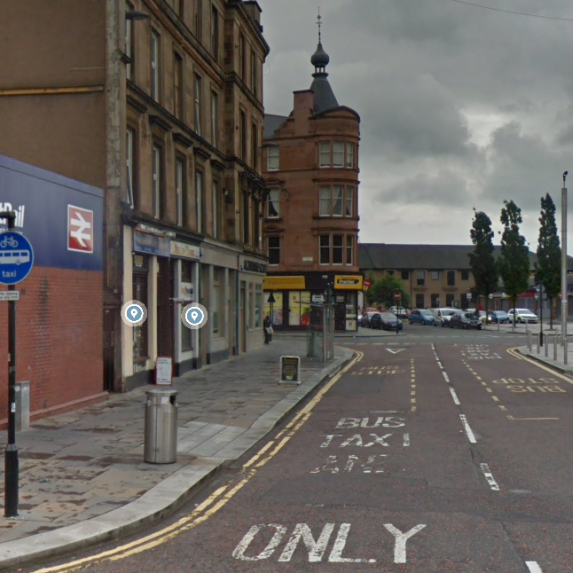
A rail replacement service will operate every half hour Monday to Sunday, in each direction. These services will pick up/drop off from London Road.
Rail replacement should be used if travelling to Exhibition Centre, Dalmarnock, Rutherglen or Cambuslang.
If travelling towards Helensburgh, Balloch, Dalmuir and Milngavie, take rail replacement to Partick and then connect with rail services.
If travelling towards Whifflet/Motherwell take rail replacement* to Carmyle and then connect with rail services.
If travelling towards Larkhall/Motherwell (via Newton), take rail replacement to Newton and then connect with rail services.
You must have a valid rail ticket to travel on the rail replacement services - these cannot be purchased onboard rail replacement. Tickets can be purchased before travelling online or via the ScotRail App , or at station ticket offices or ticket vending machines.
*This rail replacement service is operated by Clyde Gateway (CG1 service). Your rail ticket will be valid to travel on this service.
Image of Bridgeton rail replacement pick up/drop off point.
If travelling to Glasgow City Centre, use local bus services.
First Bus, services no.18, 64, 65 and 263, for travel between Bridgeton and Glasgow City Centre. You can also use First Bus, services no. 18 and 263 for travel to Rutherglen. For more information, see First Bus website.
Buy your ticket directly from the local bus operator. Rail tickets cannot be used on local bus services.
Cycling may be an option between Bridgeton and the City Centre or the other closed stations. More details can be found on Sustrans website.
There are options to hire a bike via NextBike.
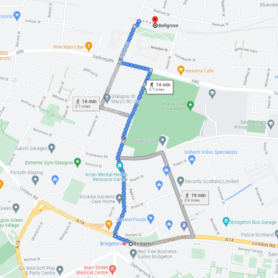
On average it takes around 15 minutes to walk from Bridgeton to Bellgrove, where you can connect with a rail service in to Glasgow Queen Street (Low Level). See map for detailed route:
Click here for details of the facilities available at the above mentioned stations.
There are no train services running to or from this station throughout the period of the closure.
Rail replacement is not a viable option for travelling to events at Celtic Park/Emirates Arena.
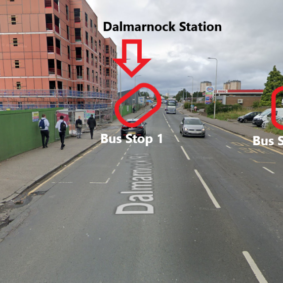
A rail replacement service will operate every half hour Monday to Sunday, in each direction. These services will pick up/drop off from Dalmarnock Road Bus Stop.
Rail replacement should be used if travelling to Exhibition Centre, Bridgeton, Rutherglen or Cambuslang.
If travelling towards Helensburgh, Balloch, Dalmuir and Milngavie, take rail replacement to Partick and then connect with rail services.
If travelling towards Whifflet/Motherwell, take rail replacement* to Carmyle and then connect with rail services.
If travelling towards Larkhall/Motherwell (via Newton), take rail replacement to Newton and then connect with rail services.
You must have a valid rail ticket to travel on the rail replacement services - these cannot be purchased onboard rail replacement. Tickets can be purchased before travelling online or via the ScotRail App , or at station ticket offices or ticket vending machines.
*This rail replacement service is operated by Clyde Gateway (CG1 service). Your rail ticket will be valid to travel on this service.
Image of Dalmarnock rail replacement pick up/drop off point.
If travelling to Glasgow City Centre, use local bus services.
First Bus, services no.18, 65 and 263, for travel between Dalmarnock and Glasgow City Centre. You can also use First Bus, services no. 18 and 263 for travel to Rutherglen. For more information, see First Bus website.
Buy your ticket directly from the local bus operator. Rail tickets cannot be used on local bus services.
Cycling may be an option between Dalmarnock and the City Centre or the other closed stations. More details can be found on Sustrans website.
There are options to hire a bike via NextBike.
There are no train services running to or from this station throughout the period of the closure.
A rail replacement service will operate every half hour Monday to Sunday, in each direction. These services will pick up/drop off from Farmeloan Road.
Rail replacement should be used if travelling to Exhibition Centre, Dalmarnock, Bridgeton or Cambuslang.
If travelling towards Helensburgh, Balloch, Dalmuir and Milngavie, take rail replacement to Partick and then connect with rail services.
If travelling towards Whifflet/Motherwell, take rail replacement* to Carmyle and then connect with rail services.
If travelling towards Larkhall/Motherwell (via Newton), take rail replacement to Newton and then connect with rail services.
You must have a valid rail ticket to travel on the rail replacement services - these cannot be purchased onboard rail replacement. Tickets can be purchased before travelling online or via the ScotRail App , or at station ticket offices or ticket vending machines.
*This rail replacement service is operated by Clyde Gateway (CG1 service). Your rail ticket will be valid to travel on this service.
Image of Rutherglen rail replacement pick up/drop off point.
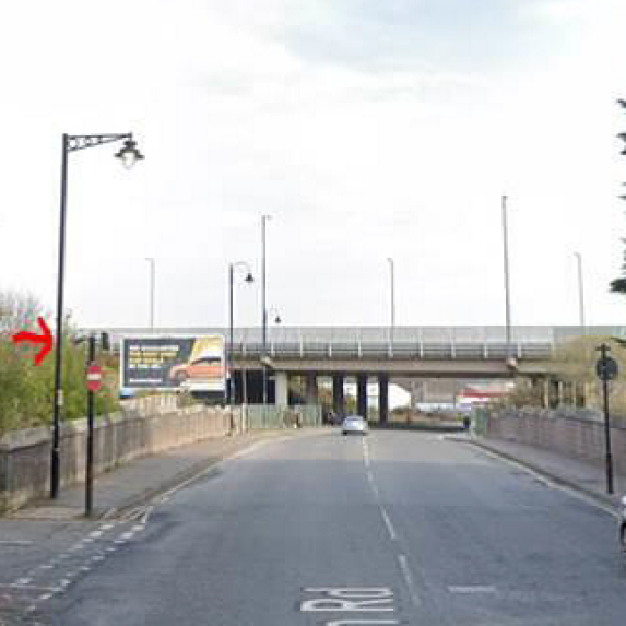
If travelling to Glasgow City Centre, use local bus services.
First Bus, services no. 7, 7A, 18, 21, 65, 263 and 267, for travel between Rutherglen and Glasgow City Centre. For more information, see First Bus website.
Buy your ticket directly from the local bus operator. Rail tickets cannot be used on local bus services.
Cycling may be an option between Rutherglen and the City Centre or the other closed stations. More details can be found on Sustrans website.
There are options to hire a bike via NextBike.
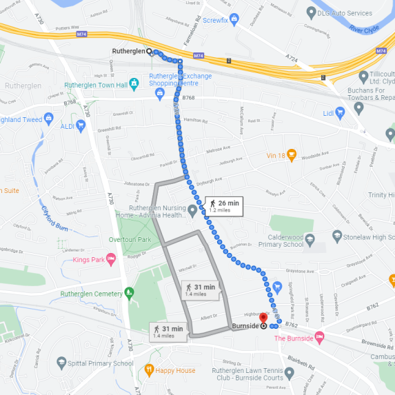
On average it takes around 25 minutes to walk from Rutherglen station to Burnside station, where you can connect with a rail service in to Glasgow Central (High Level). See map for detailed route:
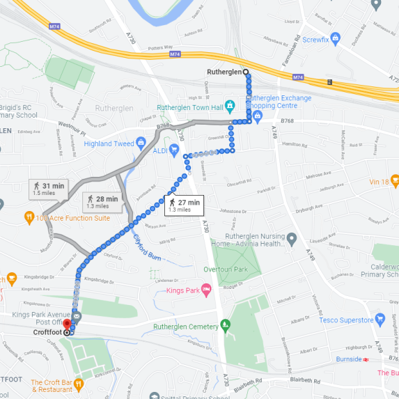
On average it takes around 30 minutes to walk from Rutherglen station to Croftfoot station, where you can connect with a rail service in to Glasgow Central (High Level). See map for detailed route:
Click here for details of the facilities available at the above mentioned stations.
Routes affected
Please see below lines of route which may be impacted by the tunnel closure:
Motherwell / Whifflet to Dalmuir via Glasgow Central Low Level
An hourly train service will operate, via Carmyle, in to Glasgow Central High Level.
If travelling towards Helensburgh, Balloch, Dalmuir and Milngavie, take the train to Glasgow Central High Level, transferring to Glasgow Queen Street Low Level for onward journey.
Rail Replacement
If travelling to Rutherglen, Dalmarnock or Bridgeton, connect with rail replacement at Carmyle.
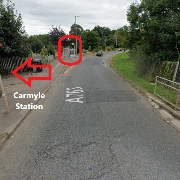
A rail replacement service* will operate every half hour Monday to Saturday and hourly on a Sunday, in each direction, from Carmyle. These services will pick up/drop off at the bus stop outside the station on the A763.
You must have a valid rail ticket to travel on the rail replacement services - these cannot be purchased onboard rail replacement. Tickets can be purchased before travelling online or via the ScotRail App , or at station ticket offices or ticket vending machines.
*This rail replacement service is operated by Clyde Gateway (CG1 service) Monday to Saturday and Abellio Rail Replacement on a Sunday. Your rail ticket will be valid to travel on this service.
Image of Carmyle rail replacement pick up/drop off point.
Local Bus Services
If you need to transfer between Glasgow Central High Level and Glasgow Queen Street Low Level, you can use bus service 398. Your rail ticket is valid for travel on this bus service.
First Bus, service no.2, for travel between Glasgow Central and the Exhibition Centre. For more information, see First Bus website.
Stagecoach, service X19, for travel between Glasgow Central and the Exhibition Centre. For more information, see Stagecoach website.
Buy your ticket directly from the local bus operator. Rail tickets cannot be used on local bus services
Active Travel - Walking
Glasgow Central to Glasgow Queen Street
If you need to transfer between Glasgow Central High Level and Glasgow Queen Street Low Level, on average it takes around 10 minutes to walk between these stations. See map for detailed route:

Glasgow Central to Anderston
If you need to transfer between Glasgow Central High Level and Anderston station, on average it takes around 15 minutes to walk between these stations. See map for detailed route:

Glasgow Central to Argyle Street
If you need to transfer between Glasgow Central High Level and Argyle Street station, on average it takes around 10 minutes to walk between these stations. See map for detailed route:

Glasgow Central to Exhibition Centre
If you need to transfer between Glasgow Central High Level and Exhibition Centre station, on average it takes around 25 minutes to walk between these stations. See map for detailed route:

Click here for details of the facilities available at the above mentioned stations.
Larkhall / Motherwell to Dalmuir via Glasgow Central Low Level
An hourly train service will operate, via Newton, in to Glasgow Central High Level.
If travelling towards Helensburgh, Balloch, Dalmuir and Milngavie, take the train to Glasgow Central High Level, transferring to Glasgow Queen Street Low Level for onward journey.
OR
Take the train to Newton, to connect with rail replacement towards Partick, then connecting back to train.
At peak periods on Monday to Friday, some trains will run limited between Newton and Glasgow Central reducing journey times. We recommend customers travelling between the city centre and stations to Motherwell and Larkhall use these services when possible:
- Depart Larkhall to Glasgow Central HL: 0633, 0728 and 0827
- Depart Motherwell to Glasgow Central HL: 0647, 0747 and 0847
- Depart Glasgow Central HL to Larkhall : 1620, 1725 and 1820
- Depart Glasgow Central HL to Motherwell: 1552, 1652 and 1753
- Services in bold are planned to have six carriages
- Services between Glasgow Central HL and Lanark also call at Motherwell every half hour in the peaks and hourly in the off peak. Almost all of these services will have six carriages.
Services, on this route, may be busier than normal, so you may find it helpful to explore other options for travel to Glasgow City Centre. First Bus run a number of services from stations along this route into Glasgow City Centre. Please see First Bus website.
Rail Replacement
If travelling to Rutherglen, Dalmarnock, Bridgeton or the Exhibition Centre, connect with rail replacement at Newton.
A rail replacement service will operate every half hour Monday to Saturday and hourly on a Sunday, in each direction, from Newton. These services will pick up/drop off from Station Car Park, Westburn Road.
You must have a valid rail ticket to travel on the rail replacement services - these cannot be purchased onboard rail replacement. Tickets can be purchased before travelling online or via the ScotRail App , or at station ticket offices or ticket vending machines.
Local Bus Services
If you need to transfer between Glasgow Central High Level and Glasgow Queen Street Low Level, you can use bus service 398. Your rail ticket is valid for travel on this bus service.
First Bus, service no.2, for travel between Glasgow Central and the Exhibition Centre. For more information, see First Bus website.
Stagecoach, service X19, for travel between Glasgow Central and the Exhibition Centre. For more information, see Stagecoach website.
Buy your ticket directly from the local bus operator. Rail tickets cannot be used on local bus services.
Active Travel - Walking
Glasgow Central to Glasgow Queen Street
If you need to transfer between Glasgow Central High Level and Glasgow Queen Street Low Level, on average it takes around 10 minutes to walk between these stations. See map for detailed route:

Glasgow Central to Anderston
If you need to transfer between Glasgow Central High Level and Anderston station, on average it takes around 15 minutes to walk between these stations. See map for detailed route:

Glasgow Central to Argyle Street
If you need to transfer between Glasgow Central High Level and Argyle Street station, on average it takes around 10 minutes to walk between these stations. See map for detailed route:

Glasgow Central to Exhibition Centre
If you need to transfer between Glasgow Central High Level and Exhibition Centre station, on average it takes around 20 minutes to walk between these stations. See map for detailed route:

Click here for details of the facilities available at the above mentioned stations.
Dalmuir to Glasgow
Services that would normally go to Glasgow Queen Street Low Level will operate as normal.
Those services that normally go to Glasgow Central Low Level will be reduced and diverted in to Glasgow Queen Street Low Level.
Glasgow Central - Edinburgh via Shotts
These services will operate as normal but will have some additional stops at Cambuslang.

